پالت Point Cloud Manager را نشان می دهد که برای کنترل نمایش پروژه های ابر نقطه ، مناطق و اسکن ها استفاده می شود.
لیست گزینه ها
با اجرای دستور گزینه های زیر نمایش داده می شود.
- دکمه های مشاهده درخت و لیست مشاهده
-
تنظیمات بین نمای درخت سلسله مراتبی و نمای لیست.
- پروژه
-
پرونده های پروژه را که به نقشه فعلی پیوست شده است ، لیست می کند.
- مناطق
-
مناطقی را که در Autodesk ReCap Pro تعریف شده اند برای ابر نقطه ضمیمه شده لیست می کند .نام منطقه را انتخاب کنید تا آنها را در رنگ اختصاص داده شده آنها برجسته کنید.
- امتیازات غیرقابل تنظیم
-
نقاط غیر واگذار شده یا بخش هایی از ابر نقطه که به مناطق اختصاص داده نشده است را شناسایی و مخفی می کند . ردیف را انتخاب کنید تا نقاط دست نخورده را نشان دهید.
- اسکن می کند
-
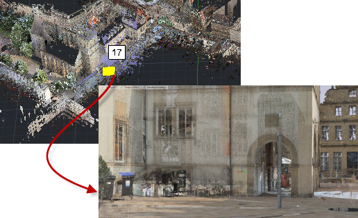
پرونده های اسکن فردی را که در ابر نقطه کامپوزیت موجود است لیست می کند. برای برجسته کردن نقاط موجود در اسکن ، ردیف را انتخاب کنید . یک برچسب به طور موقت در صحنه نمایش داده می شود تا مکان را مشخص کند.بر روی یک اسکن در Point Cloud Manager دوبار کلیک کنید تا ابر نقطه از نقطه برتری مکان دوربین برای آن اسکن مشاهده شود.
- برای نمایش یا پنهان کردن مناطق یا اسکن ها
-
برای پنهان کردن منطقه یا اسکن ، روی دکمه سمت راست ردیف کلیک کنید.
- جستجو کردن
-
جستجو بر اساس نام یک ابر ابر ، منطقه یا پرونده اسکن.
POINTCLOUDMANAGER (Command)
Displays the Point Cloud Manager palette, used to control display of point cloud
projects, regions, and scans.
List of Options
The following options are displayed.
- Tree View and List View buttons
-
Toggles between a hierarchical tree view and a list view.
- Project
-
Lists project files that have been attached to the current drawing.
- Regions
-
Lists the regions that have been defined in Autodesk ReCap Pro for the attached point
cloud.Select the region names to highlight them in their assigned color.
- Unassigned Points
-
Identifies and hides unassigned points, or sections of the point cloud that have not
been assigned to regions. Select the row to show the unassigned points.
- Scans
-
Lists the individual scan files that are included in the composite point cloud. Select
the row to highlight the points included in the scan. A tag is temporarily displayed
in the scene to identify the location.Double-click a scan in the Point Cloud Manager to view the point cloud from the vantage
point of the camera location for that scan.
- To Show or Hide Regions or Scans
-
To hide a region or scan, click the button to on the right end of the row.
- Search
-
Searches by name for a point cloud, region, or scan file.


