GEOMARKLATLONG (فرمان)
یک نشانگر موقعیت را در مکانی که توسط عرض جغرافیایی و طول جغرافیایی تعیین می شود ، قرار می دهد.
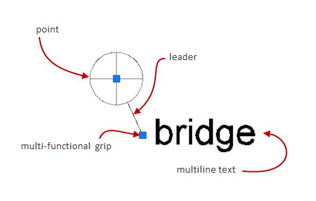
این دستور معادل گزینه Lat-long فرمان GEOMARKPOSTION است. نشانگرهای موقعیتی حاشیه نویسی هستند که مکان ها را نشان و نشان می دهند. یک نشانگر موقعیت به طور معمول از یک نقطه ، یک خط رهبر و متن چند خطی تشکیل شده است.
این دستور فقط درصورتی موجود است که فایل نقاشی شامل اطلاعات موقعیت جغرافیایی باشد.
با اجرای دستور پیام های زیر نمایش داده می شود.
- عرض جغرافیایی
-
عرض جغرافیایی محل را مشخص می کند. می توانید عرض جغرافیایی را در درجه های اعشاری یا درجه / دقیقه / ثانیه تعیین کنید. این فرمان ، عرض جغرافیایی را تأیید می کند ، به طوری که بین +90 آ ؛ و -90 آ باشد.
- عرض جغرافیایی
-
طول جغرافیایی محل را مشخص می کند. می توانید عرض جغرافیایی را در درجه های اعشاری یا درجه / دقیقه / ثانیه تعیین کنید. این فرمان طول جغرافیایی را تأیید می کند که بین +180 آ و -180 آ باشد.
GEOMARKLATLONG (Command)
Places a position marker at a location defined by latitude and longitude.
This command is equivalent to the Lat-long option of the GEOMARKPOSTION command.
Position markers are annotations that indicate and label locations. A position marker
typically consists of a point, a leader line, and multiline text.
This command is available only if the drawing file contains geographic location information.
The following prompts are displayed.
- Latitude
-
Specifies the latitude of the location. You can specify the latitude in decimal degrees
or degrees/minutes/seconds. The command validates the latitude so that it is between
+90آ؛ and -90آ؛. - Longitude
-
Specifies the longitude of the location. You can specify the latitude in decimal degrees
or degrees/minutes/seconds. The command validates the longitude so that it is between
+180آ؛ and -180آ؛ .